")
")
Information about the Source du Castor
Die Gorges de l‘Ardèche
In the southeast of France and in the Auvergne-Rhône-Alpes region, the Ardèche River rises in the Mont d'Ardèche Nature Park. On its way to its mouth in a branch of the Rhône, the Ardèche makes its spectacular way through the Gorges de l'Ardèche. This area is known for its landscape and the many caves and is a popular destination for water sports (canoe, kayak, ...) and hikers who enjoy the nature and views from the Pont d'Arc in the northwest to about 30km further downstream in Saint-Martin-d'Ardèche).
The Gorges de l'Ardèche, with its unique fauna and flora, has been a national nature reserve since November 2018, covering an area of about 2000 ha. On this area, on the one hand, the protection of nature but also the awareness and experience of nature are in the foreground. Therefore, the whole area is subject to strict rules, which should allow a peaceful coexistence of nature and visitors. The people in charge of the area do not want to make the reserve inaccessible to visitors by imposing strict prohibitions, but rather to make it possible to experience nature by means of guidelines and rules, without burdening it too much. At the same time, exploration of the reserve is still taking place. For example, drones are prohibited in the entire nature reserve without permission. This is not just about avoiding noise, but above all about protecting the birds of prey that live there.
The goal of this year's expedition was the Source du Castor, which is located downstream from Pont d'Arc on the right side near the famous rock formation "cathédrale".
If you want to visit / explore caves in the Gorges de l'Ardèche, this venture must be coordinated and approved with the managers of the nature reserve. Especially in the case of explorations, these should be submitted by January 31st of the planned year. At the same time, the results of the exploration must be shared with the responsible authorities.
In the preparation of our project, we applied for this approval and coordinated with the responsible authorities. They were open-minded towards our project, but we had to write down all the information about the project (goal, planned dives, number of divers, etc.). After we provided all the information about the process, our project was approved for 2019. In addition, we were asked to document a little more in the front area in addition to our search for a continuation. During the project, the people in charge also visited us to get to know us and gave us insights into their work. In the course of the visit, it has become clear that the responsible persons, it is about a togetherness and is not the ultimate goal to prohibit any activities.
The cave Source du Castor
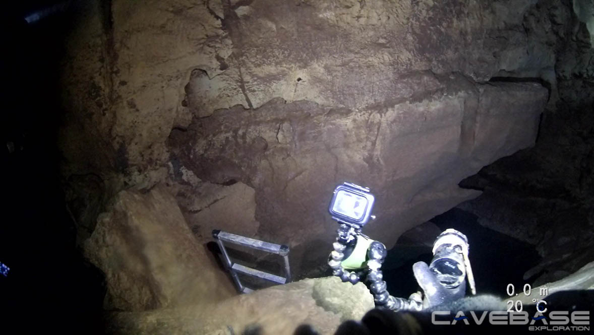
The Source du Castor is an underwater cave whose entrance is located on the bank of the Ardèche River. The cave can be dived through two narrow openings. Parts of the entrance are permanently under the water surface, so the cave cannot be entered dry.
History of cave exploration (source: www.plongeesout.com)
- It is not known when the cave was discovered. First explorations were carried out by the G.E.P.S and local divers.
- In 1979 the S.C. Paris accompanied by F. LE GUEN explored the cave on a length of 430m and a depth of 50m.
- In 1981 the Swiss diving group G.L.P.S. had reached the deepest point of the cave at 68m and explored the cave to 640m.
- 2005 Fred Badier & Xavier Meniscus find a continuation and Xavier Meniscus continuously extends the cave to 800m until 2008. There the cave ends in the Salle Chaotique, where you have to surface:
- Exploration video by Xavier Méniscus (2008): https://www.youtube.com/watch?v=biVvFMhiLjU
- Virtual dive by Frank Vasseur: https://vimeo.com/259255077
Simplified cave course (source: youtube, by Fred Badier and Xavier Ménisus)
Salle Chaotique
The name of the Salle Chaotique can be derived from the 1st view that a diver has when surfacing from Sump1. You see a huge hall that continues in the direction of 210°, where you can only guess the end. In front of you there are large rocks that look like they have fallen from the ceiling. These ensure that the steps are from 1m to 5m (entry S2). Thanks to a submerged place on the platform in front of exit Sump 2, it is relatively easy to enter the dry area to the Salle Chaotique and put down the diving equipment. Once that is done, you either have to climb up a ladder 3m to the next platform or crawl on all fours past it on the right to continue climbing over sharp rock edges, deep holes in between or clay-filled puddles on the versturz rocks. The climb is a total of 5m high.
An analysis of the breathing air gave the following result:
- CO: >= 5% (maximum value of the analyzer used).
- O2: 14,7%
!!! Attention: Breathing air in the Salle Chaotique is toxic !!!

Sketch of the Salle Chaotique
Only now one recognizes the extent of the Salle Chaotique and can see the respective ends. At the highest point one stands then before the entrance of Sump 2, can marvel at its "CRISTAL CLEARES" water and has a great view in both directions over the huge nave, which is the shape of the Salle Chaotique (L: 35m, W: 15m & H: 16m). Only above Sump 2 at the southeast corner the rectangular shape is unsymmetrically broken out and follows somewhat the course of the Donut Sump. The outcropping rocks are found underwater in Donut Sump.
View from the highest point of the Salle Chaotique to the pool of S2 (Donut Sump)
In addition, at the highest point towards 300° is a 1.5m high & wide corridor. The corridor, which winds left, right, left, right after the access, rises slightly and ends in a large room of about 8 x 6m. The special feature is the height of the room. It is up to 20m high and looks like the bell tower to the nave "Salle Chaotique". Since there is a direct connection, it can be concluded from the gas analysis that there is no connection to the surface at the top of the bell tower. Turning off the light also did not yield any results. At the time of exploration, no flowing water could be detected between S1 and S2.
Only by lowering a ladder from the highest point to S2, it is possible to overcome the 5m high wall with or without diving equipment and continue to the pool of S2. The clear water gets cloudy very quickly by putting on the equipment, but recovers acceptably fast. Furthermore, one should watch out for the sharp-edged rocks in the water.
S2 : Donut Sumps
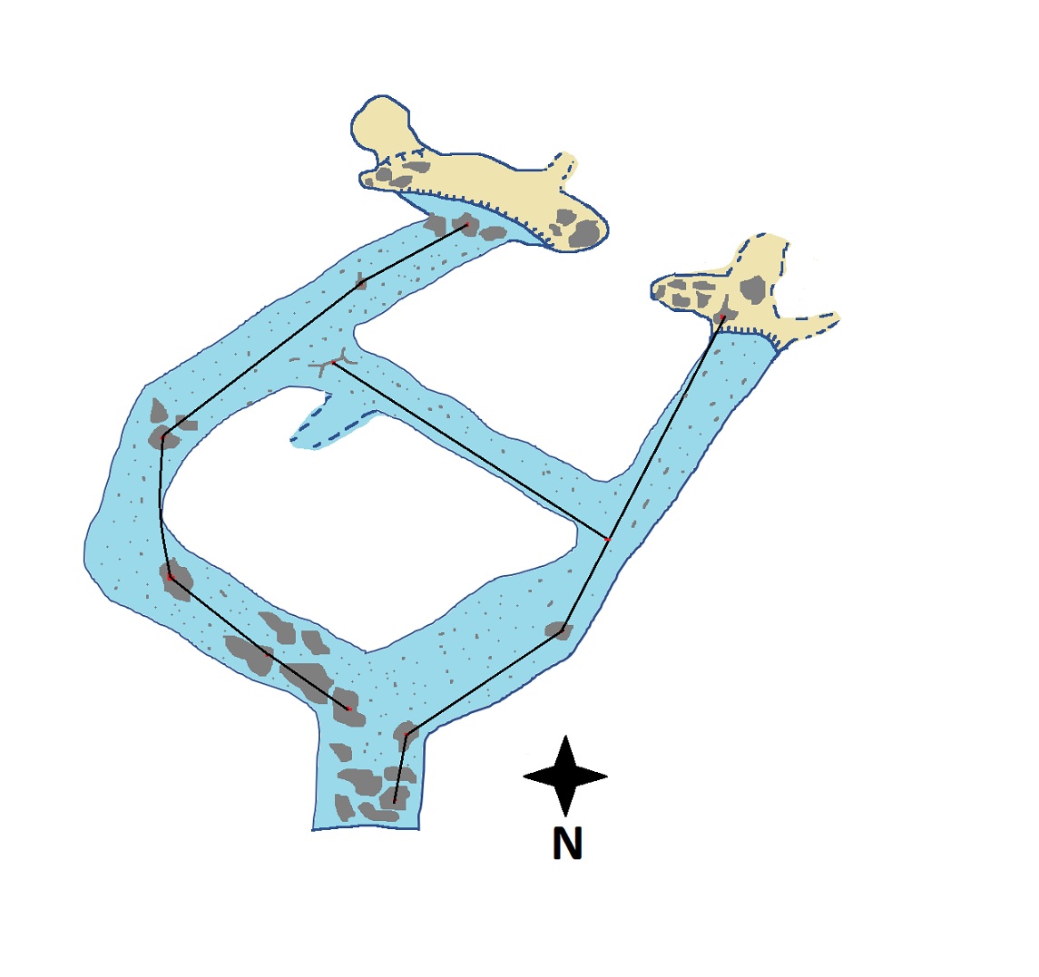
Course of the donut dump incl. the relocated line. In the north the two new emergence points
After the descent, after about 20m you are at the entrance to the Donut Sump at a depth of 8m. Following the main line to the right, a corridor of about 2.5 x 2.5m opens up. This west passage runs quasi in extension to the Salle Chaotique in direction 210°. Slightly ascending to the western exit of S2 over a length of about 40m one finds some fossil tower snails "Turritellidae."

Tower snails in Donut Sump
There are no rocks in the entire passage, only a little loamy sand lies at the bottom, so that in the smooth passage no placement of the mainline is possible.
At the ascending exit in the southwest you find again the first rock to which the mainline is attached. After taking off the diving gear you will find a room of 10m depth, 6m width and 3m height. The room is divided by a large rock (2m wide, 1.5m high) in the direction of the south to a 1/4. Behind the rock, at the southern end, there are 2 tunnels of 1 x 1m, which are definitely still to be explored. However, the rock can be overcome only with light equipment.

Southwest emergence point of the Donut Sumps
Turning now toward S2, it appears as if there is a large rock hanging over the pool. Due to the washing out of the side of the passage, the shallower ceiling above has a rounded shape. While exploring both dry areas beyond S2, a rush of water from the south was very audible, but no flow or watercourse could be heard in Donut Sump itself.

View towards the pool of Donut Sump at the southwestern emergence point
An analysis of the breathing air yielded the following result:
- CO: >= 5% (maximum value of the analyzer used).
- O2: 14,7%
!!! Attention: Breathing air in the Salle Chaotique is toxic !!!
The southern cross passage from east - west has a slightly curved shape, is 5m wide and maximum 3m high. The main direction according to the dive course is 150° and about 25m long. The passage has the same smooth appearance of the rock as in the west passage. Some clay-sand mixture at the bottom and light karst rock. As a special highlight, after 2min of diving at a depth of 3m, you reach the east passage via 2 archways of different sizes. These separate the south passage from the east passage and are divided by gate posts.

View of the archway in the connecting corridor leading from east to west
Shortly before these archways there is a tapering bulge at the north-east corner of the southern passage. As a continuation to the something this bulge can be excluded.

View of a taper without continuation in the connecting corridor
The exit southeast from Donut Sump has somewhat steeper bank with only a very short flat dry area. There are 2 "holes" here that need to be explored in more detail with much lighter equipment. To get further here, a slim OC sling bag combination would again be needed to climb over the rocks with appropriate safety.


Pictures from the drying area at the southeast exit of the Donut Sumps
The karst formations at the bottom did not allow us to measure the ambient gases. We noticed the same kind of water noise as in the parallel exit of S2. Only a bit quieter. This suggests the same gases, as there is probably a connection. The bottom of the pool has a number of stumpy rocks lying at the bottom, many of which are riddled with petrification. In total, the vault above the pool from the southeast exit has 8m E-W and 4m N-S with a maximum height of 3m above water.

Dry area southeast emergence point
Also the eastward passage de Sumps has a smooth karst structure in the direction 210° from the entrance. The southern half has a flat floor and is here about 5m wide and 2m high. Here you can also find fossilized tower snails on the floor, which are felt to be harder than the karst itself. Compared to the previous passages, there is a large longitudinal clay-sand bank here.
Marked with smaller sturgeon rocks, towards the north the floor turns into a gully. In this area there are larger crevasses and circular holes in the ceiling along the length, but these prevent climbing. Furthermore, there is also a larger crevice here at 7m on the western side towards the ceiling, which can be dived at most with a sidemount system. Here the east passage narrows to 2 x 2m. In total, the east passage has a length of about 40m.


Pictures from the southeast corridor
The deepest point of the Donut Sump is in the cave knee north to the east passage at 11m. The north cross passage east-west runs parallel to the south passage at 150° and about 25m long. Starting at the cave knee slowly feels the ground with small versturzfelsen. These versturzfelsen become larger and larger as you get closer to the entrance S1. Very fine sediment lies on the versturz rocks, which leads to a rapid clouding of visibility. Shortly before reaching the entry pool of S2, the line is interrupted with a jump to the main line. From here, the light of the waiting surface supporter can already be seen.
In this sense
Your Cavebase